Storm Formation Imminent in the Gulf of Mexico
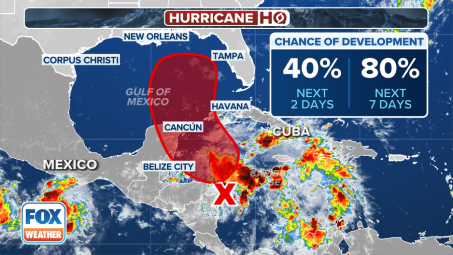
The Gulf of Mexico is under close watch as meteorological conditions hint at the formation of a new tropical storm, potentially named Helene, within the next few days. The National Hurricane Center (NHC) has been tracking a system, currently known as Invest 97L, which is showing increasing signs of organization over the northwestern Caribbean Sea.
System’s Path and Development
As of the latest updates, this system is expected to move northward, entering the southeastern Gulf of Mexico. Environmental conditions are ripe for its development, with warm sea surface temperatures and low wind shear providing a conducive environment for tropical cyclogenesis. The NHC has indicated a high likelihood that this system could evolve into a tropical depression or storm by mid-week.
Potential Impacts Across Central America and the Gulf
Even without official storm status, Invest 97L is already influencing weather patterns, expected to bring heavy rainfall across parts of Central America. This could lead to flooding and landslides in regions already susceptible to such weather-related hazards. Residents and authorities in the northwestern Caribbean, the Yucatan Peninsula, and western Cuba are advised to remain vigilant and prepare for possible impacts.
Gulf Coast Residents on Alert
The trajectory of the system suggests a northward movement across the eastern Gulf of Mexico, placing the northeastern Gulf Coast, including parts of Florida, Alabama, and Mississippi, on alert. Residents are encouraged to monitor the storm’s progress closely, with preparations for potential hurricane conditions advisable. The NHC’s forecasts indicate that by the end of the week, this system could bring not only heavy rains but also strong winds and significant storm surges to coastal areas.
Historical Context and Preparedness
This potential storm comes at a time when the Gulf of Mexico has seen increased activity due to climate patterns favoring storm development. The region has a history of being hit by significant storms, with past events like Hurricane Katrina serving as stark reminders of the need for robust emergency preparedness. Local governments and emergency services are gearing up, with shelters, evacuation routes, and disaster response teams being readied.
Conclusion: A Watchful Eye on Helene
As the week progresses, all eyes will be on Invest 97L, which could soon be Tropical Storm Helene. The NHC’s updates will be crucial for residents and authorities along the Gulf Coast to make informed decisions regarding safety measures and storm preparations. The potential for this system to intensify underscores the importance of staying informed and prepared in hurricane-prone areas.
Disclaimer: The information provided is based on current meteorological data and forecasts. Weather conditions can change rapidly, and individuals should refer to the National Hurricane Center for the most up-to-date information and safety guidelines.


