

Southwestern Michigan experienced a devastating bout of severe weather on Tuesday, with powerful tornadoes and storms causing extensive damage to homes and businesses and injuring several residents. As the region reels from the impact, further severe weather warnings signal that the threat is far from over.
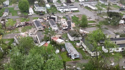
On Tuesday evening, a tornado tore through Pavilion Estate Mobile Home Park in Kalamazoo County, Michigan, resulting in injuries for more than a dozen individuals. Local emergency services transported approximately fifteen to twenty people with minor injuries to nearby hospitals. The community’s resilience is being tested as they face significant destruction in their homes and local infrastructure.
In addition to Kalamazoo, other Michigan areas, including Portage and Centreville, reported extensive damage due to possible tornadoes. In Portage, homes and a FedEx facility were severely damaged, and downed wires temporarily trapped around fifty people. Centreville and nearby Branch County saw homes completely flattened, with Branch County experiencing Michigan’s first-ever tornado emergency due to a particularly large and destructive tornado.
This severe weather period is typical for this time of year in the United States, as April through June marks the most active tornado season. The past two weeks alone have witnessed an unbroken streak of daily tornado occurrences across the country, with nearly 300 tornado reports, including some as severe as EF4.
As Wednesday unfolds, nearly 4 million people across Missouri, Illinois, Kentucky, and Tennessee face a high Level 4 of 5 risk for severe thunderstorms, while an additional 50 million people are under moderate to considerable risk across several states. Morning storms in parts of eastern Kansas are expected to set the tone for the day, potentially forming a powerful line of storms that could bring widespread damaging winds. If these storms do not form as expected, the risk for strong, isolated tornadoes increases.
The day will continue to see storms develop and strengthen across a broad swath of the country, from the Southern Plains to the mid-Atlantic. These storms are capable of producing damaging winds and large hail, with the possibility of hailstones as large as softballs.
Furthermore, the severe weather threat extends beyond tornadoes and high winds. Heavy rainfall expected throughout the day raises significant concerns about flash flooding, especially in Kentucky and Tennessee and neighboring states. Rainfall rates could peak at 2 inches per hour, posing a high risk of flash floods in areas already saturated by earlier storms.
This ongoing severe weather event highlights the relentless power of nature and the need for preparedness and vigilance in affected regions.